Backtrack by Trump Admin? USTR Removes Controversial India Map Post Amid Growing Geopolitical Buzz
In a significant diplomatic development, the office of the United States Trade Representative (USTR) has backtracked on a social media post that featured a map of India including Pakistan-occupied Kashmir (PoK) and Aksai Chin as integral parts of the country. The deletion of the post from X (formerly Twitter) on Wednesday follows days of intense speculation regarding whether the map represented a major policy shift under the Trump administration or was merely an inadvertent technical error.
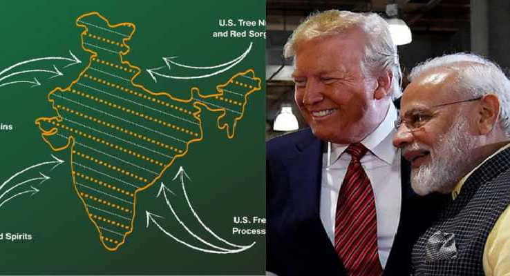
The controversy began on February 8, when the USTR released an official graphic alongside the announcement of a new interim trade framework between Washington and New Delhi. Unlike previous US government maps that typically demarcated PoK and Aksai Chin to reflect their disputed status, this particular map showed the entire region within India’s borders. This alignment with India’s long-standing sovereign claims initially sparked excitement in New Delhi, suggesting a potential recalibration of US-India ties and a stronger stance against Pakistan and China.
While the trade deal itself marks a significant milestone—reducing US tariffs on Indian goods from 50% to a historic low of 18%—the sudden removal of the map post has raised eyebrows. Simultaneously, the White House updated its factsheet on the deal, softening language around India’s purchase commitments. Observers suggest the deletion may be a tactical retreat to avoid immediate friction with Islamabad and Beijing. However, the episode has once again brought the sensitivity of India’s borders to the global forefront, as New Delhi remains firm that the entire Union Territory of Jammu & Kashmir is, and always will be, an inalienable part of India.

- Author
- "It was for Bangladesh, not against India!" PCB Chief Mohsin Naqvi’s shocking claim ahead of Colombo clash February 11, 2026
- Tulbul Project to Restart? CM Omar Abdullah Announces Fresh Push for Stalled J&K Hydel Works February 11, 2026
- PM Modi to Land on Assam Highway! A Historic Leap in Infrastructure & Defense at Moran on Feb 14 February 11, 2026
- Indian Markets Underperform Global Peers in Jan 2026; Nifty 50 Slumps Over 3% February 11, 2026
- Major Shake-up at Nabanna Ahead of Polls! Home Secretary Relieved of Key Department Duties! February 11, 2026